Entry
Bhutan Permits, Visas and the SDF
Indian, Bangladeshi and Maldivian nationals need a permit, not a visa. What documents to carry, where it is issued, what the SDF costs and how long it takes.

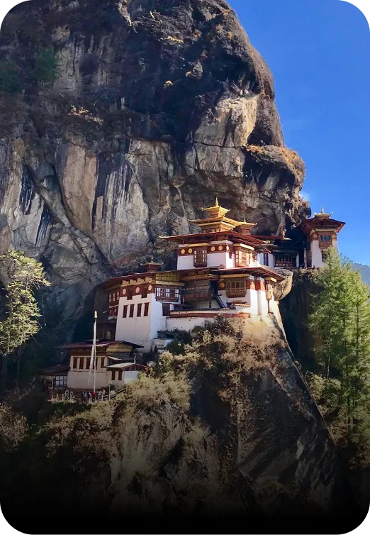
Nothing on Bhutan’s western circuit is technical, but the altitudes are real: Thimphu sits at 2,320 m, Phobjikha at 3,000 m and Chele La at 3,988 m. The Tiger’s Nest is a 900 m ascent over roughly 4 km each way, four to five hours return at a steady pace. Most reasonably fit people manage it.
| Place | Altitude | You are there for |
|---|---|---|
| Phuentsholing (border) | 300 m | Entry, a night at most |
| Punakha | 1,200 m | 1–2 nights |
| Paro | 2,200 m | 2–3 nights |
| Thimphu | 2,320 m | 1–2 nights |
| Phobjikha | 3,000 m | 1–2 nights |
| Dochula Pass | 3,100 m | A 30–45 minute stop |
| Taktsang (Tiger’s Nest) | 3,120 m | A half-day climb |
| Chele La | 3,988 m | A stop, and a ridge walk if you want it |
Altitude sickness is uncommon on this circuit, because you sleep low — mostly between 1,200 m and 2,320 m — and only touch 3,000 m and above during the day. That is a much gentler profile than a Ladakh or Everest region trip, where people sleep high from day one.
Taktsang is the one thing on a Bhutan trip that requires something of you physically. The trail climbs roughly 900 m over about 4 km from the car park to the monastery, on a well-made path of dirt, stone steps and, near the top, a staircase down into the gorge and back up the other side.
| Section | Time | What it is like |
|---|---|---|
| Car park to the cafeteria | 1–1.5 hr | Steady uphill on a wide track. Horses can carry you this far. |
| Cafeteria to the viewpoint | 45–60 min | Narrower, still climbing, the first full view of the monastery. |
| Viewpoint to the monastery | 30–45 min | Around 700 stone steps down into the gorge and back up. |
| The descent | 1.5–2 hr | Easier on the lungs, harder on the knees. |
Four to five hours return at a steady pace, longer if you stop. Horses are available to the halfway cafeteria and no further — the section above it has to be walked, and so does the whole descent. Anyone who cannot manage the upper section should plan to turn around at the cafeteria, which has a clear view across the gorge and is a perfectly good place to end the morning.
Mild headache and breathlessness on the first day at 2,300 m are normal. Persistent headache that does not respond to fluid and rest, nausea, dizziness, or sleeplessness combined with any of those, are not — tell your guide rather than pushing through. The answer at these altitudes is almost always to descend a few hundred metres, and on this circuit that is thirty minutes in a car.
The circuit itself is gentle and is done regularly by both. Drives are long but the roads are paved, and nothing except Taktsang asks for sustained effort.
For older travellers or anyone with a cardiac or respiratory condition, get a doctor’s clearance before booking, tell us in advance, and treat the Taktsang climb as optional from the outset rather than deciding on the morning. For children, the SDF is halved between 6 and 12 and waived under 6, and the usual limiting factor is the length of the drives rather than the altitude.
Moderate. The trail climbs about 900 m over roughly 4 km each way, taking four to five hours return at a steady pace, and finishes with around 700 stone steps down into the gorge and back up. It is not technical, but it is sustained uphill at about 3,000 m.
Only as far as the halfway cafeteria. The section above it, and the entire descent, must be walked. If you cannot manage that, the cafeteria has a clear view across the gorge to the monastery and is a reasonable place to stop.
It is uncommon on the western circuit, because you sleep between 1,200 m and 2,320 m and only reach 3,000 m and above during the day. Mild headache and breathlessness on the first day are normal; persistent symptoms should be reported to your guide, and descending is easy here.
Chele La, at 3,988 m, the highest motorable pass in Bhutan, on the Paro–Haa road. Dochula Pass is 3,100 m and Taktsang about 3,120 m. You do not sleep at any of these altitudes on a standard itinerary.
Indian, Bangladeshi and Maldivian nationals need a permit, not a visa. What documents to carry, where it is issued, what the SDF costs and how long it takes.
October and November give the clearest mountain views, March to May the rhododendron and the big tshechus. Month-by-month weather, festivals and trade-offs.
Ngultrum is pegged 1:1 to the rupee and INR is accepted widely. Where cards work, which notes get refused, where the ATMs are and how much cash to carry.
Long trousers and covered shoulders in every dzong, shoes and hats off, no photography inside, walk clockwise. The rules Bhutan is genuinely firm about.
A packing list built around real conditions: 1,200 m to 3,988 m in one day, temple dress codes, the Taktsang climb, and a country that runs on small notes.
Ask us anything about Bhutan, even if you never book. We would rather you arrived well prepared.
Talk to a Bhutan specialist →